As infrastructure ages and the risk of failures increases, concerns about safety and mobility among drivers and pedestrians are raised, posing economic challenges for taxpayers. A recent study published in the "Transportation Research Record" reveals that high-resolution Synthetic Aperture Radar (SAR) satellite data can help detect infrastructure issues early, akin to an annual health check preventing serious health issues. Such early detection is crucial in preventing further deterioration of roads.
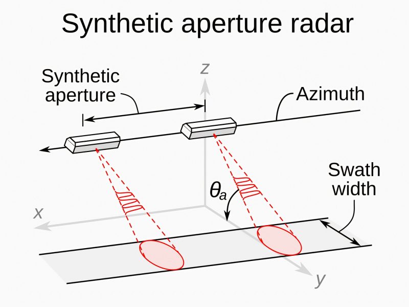
Researchers at Texas A&M University are exploring novel methods for monitoring infrastructure using SAR remote sensing systems. SAR enables researchers to inspect and characterize road surfaces, retaining walls, and levees from space, aiding in identifying defects that require further inspection or repair, thereby saving valuable time.
The researchers note that while the traditional process from data collection to pinpointing faulty areas typically takes 5 days in a region, satellite monitoring allows for data review and decision-making within just two days, significantly expediting time savings.
In addition to saving time on maintenance and preventive measures for agencies, utilizing satellite monitoring for infrastructure and road condition assessment has the potential to reduce the costs of managing road infrastructure assets. Furthermore, SAR remote sensing technology has been employed in studying landscape changes, as well as sudden movements like earthquakes and landslides.
Tags
A new study reveals that Earth's civil and military radar systems may be inadvertently transmitting signals into space that could be detected by alien civilizations. These unintended electromagnetic emissions—especially from…
Mountains are among the most biodiverse ecosystems on Earth, yet global environmental changes are profoundly reshaping them. Over the past 50 years, rising temperatures and shifts in land use have…

On March 28, 2025, a powerful magnitude 7.7 earthquake struck near Mandalay, Myanmar, followed by a magnitude 6.7 aftershock. Both quakes occurred along the Sagaing Fault—a major strike-slip fault running…

A team of international researchers is calling on the United Nations to incorporate Earth’s orbital protection into its Sustainable Development Goals (SDGs). Led by experts from NASA’s Jet Propulsion Laboratory…

NISAR, a collaborative project between NASA and the Indian Space Research Organization (ISRO), is an upcoming radar satellite poised to revolutionize Earth observation. As the first satellite equipped with unique…
The research team at the Korean Institute of Science and Technology has developed a new radar signal processing technology that significantly enhances the resolution of existing low-resolution radars without the…